


What You Need To Know about Mossel Bay
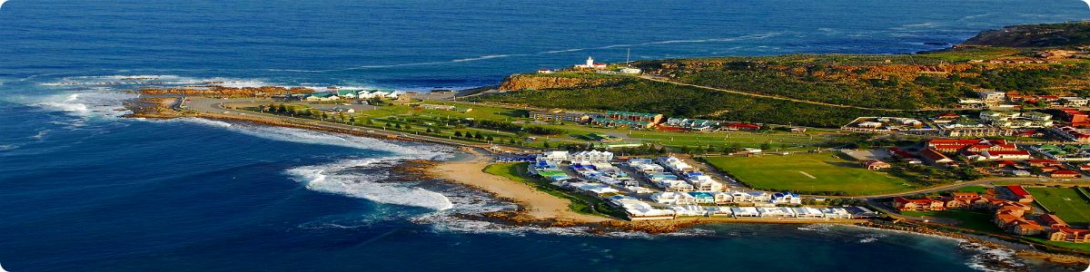
Mossel Bay is a harbour town of about 130,000 people on the Southern Cape (or Garden Route) of South Africa. It is an important tourism and farming region of the Western Cape Province. Mossel Bay lies 400 kilometres east of the country’s seat of parliament, Cape Town (which is also the capital city of the Western Cape Province), and 400 km west of Port Elizabeth, the largest city in the Eastern Cape Province. The older parts of the town occupy the north-facing side of the Cape St Blaize Peninsula, whilst the newer suburbs straddle the Peninsula and have spread eastwards along the sandy shore of the Bay. The town’s economy relied heavily on farming, fishing and its commercial harbour (the smallest in the Transnet Port Authority’s stable of South African commercial harbours), until the 1969 discovery of natural offshore gas fields led to the development of the gas-to-liquids refinery operated by PetroSA. Tourism is another driver of Mossel Bay’s economy.
Population: Estimate 133, 178
Area: 42,2 km²
Currency
Language
English is the Official language.
Rock Art
The mountains to the north of Mossel Bay are an important repository of South African rock art. This art, which is now associated with shamanistic practices (in which the rock itself is thought to have been considered the veil between this world and the spirit world), was created by the San people, and specimens may date back as far as 27,000 years. The rock art sites surrounding Mossel Bay are generally located on private land, and are therefore only accessible to the public in the company of registered guides, who will ensure that the integrity of the pieces remains intact.
Post Office Tree
In 1501, another Portuguese navigator, Pedro d’Ataide, sought shelter in Mossel Bay after losing much of his fleet in a storm. He left an account of the disaster hidden in an old shoe which he suspended from a milkwood tree (Sideroxylon inerme) near the spring from which Dias had drawn his water. The report was found by the explorer to whom it was addressed — João da Nova — and the tree served as a kind post office for decades thereafter. (More recently, a boot-shaped post box has been erected under the now famous Post Office Tree, and letters posted there are franked with a commemorative stamp. This has ensured that the tree has remained one of the town’s biggest tourist attractions.) João da Nova erected a small shrine near the Post Office Tree, and although no traces of it remain, it is considered the first place of Christian worship in South Africa.
Topography
Mossel Bay straddles the Cape St Blaize peninsula (which rises to an average height of 96 metres), and spreads out along the sandy shores of the Indian Ocean, eastwards towards the town of George. The Outeniqua Mountains, which form part of the Cape Fold Belt, lie to the north of the municipal area. These mountains of sandstone and shale are characterised by gentle slopes to the seaward side (which are generally covered by montane fynbos and grasslands), and rise to a height of 1,578 m at Cradock Peak, near George (40 km east of Mossel Bay), and 1,675 metres at Formosa Peak near Plettenberg Bay (150 km east of Mossel Bay). To the east, the land slopes upwards towards the wave-cut platform (average elevation 245 metres) that characterises the more lush all-year-round rainfall area of the Garden Route. Here the land is mostly covered by grass and farmlands. The deep sandy soils of the western portion of the municipal area also give way to grass and farm-lands, with large stands of typically dry fynbos which are characterised by, amongst others, the Aloe ferox (also known as the bitter aloe, Cape aloe or red aloe) from which skin-care products are made locally, and the Chondropetalum tectorum (Cape or thatching reed) which is used for the roofing of traditional Cape-Dutch buildings. The municipal area’s boundaries are the Gouritz River in the west, the Outeniqua Mountains to the north, the Maalgate River in the east, and the Indian Ocean to the south.
Tourism
Transport
Road transport
Mossel Bay straddles the N2 national highway, which is South Africa’s main coastal road from Cape Town in the Western Cape Province, to Durban in KwaZulu-Natal Province. (Using this route, Mossel Bay lies exactly at the midpoint between Cape Town and the Eastern Cape Province’s capital of Port Elizabeth — 400 km each way). The Municipality of Mossel Bay maintains 417,9 km of paved and concreted roads, and 24 km of gravel roads. Mossel Bay is a stopping point for all major road transport operators licensed for this region.
Harbour
Rail
Weather
Mossel Bay’s climate is mild throughout the year as the town is situated in the area where the winter rainfall and all-year rainfall regions of the Western Cape Province meet. Its weather is influenced by the Agulhas Current of the Indian Ocean to the south, and by the presence of the Outeniqua Mountains to the north. Mossel Bay receives 80{2d3398b9a6af368e27cb7b3813f729087c040c7f1495c626b6aae26b161dc686} of its rainfall at night. Frost is rare or almost absent and snow has never been recorded on the coastal platform. Snow does, however, occasionally fall on the mountain peaks and can be seen from the town on rare occasions. Prevailing winds are westerly in winter (May – August) and easterly in summer (September – April), and rarely reach storm- or gale-force strength. The average days of sunshine are 320 days per year.